I'm still learning about all the cool features available to me through Geocaching.com and GSAK. Last week I was planing my short vacation and I was asking myself, "How do I create pocket queries along a route?" I didn't want to find caches along some auto generated driving directions. I wanted to find geocaches along a route that I made up. Well believe it or not, I actually figured something out and it worked! I wanted to share it with you because I love my readers. (It's getting thick in here!)
The first thing you need to do is install and open Google Earth.
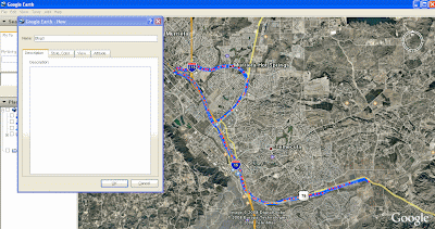
- In the tool bar click on "Add" and then "Path"
- The new path window will appear where you can title it and edit the appearance of the line you are creating .
- The mouse pointer will turn into a square target box.
- Hold the left mouse button and drag it to trace your path. (You can let go of the button to move the view and click it again and keep going)
- When you are done, click "OK" in the new path window.
- You will now see your path name n the "My Places" area on the left side of the screen.
- Click on the new path you created and then on the tool bar click File, Save, Save place as.
- Make sure to change the file type to .KML (Not .KMZ which is the default.)

Now to create the Pocket Query.
- Go to Geocaching.com.
- Click on "Find Caches along a route"
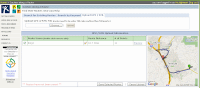
- Click on "Upload GPX/KML"
- Browse to where you saved the file and click "up load"
- Your new path will appear on the screen. Click "Preview" to see it on the map.
- Select the path by checking the box and click "Save"
- Click on the "Your created routes" tab and click on "Create Pocket Query"
- Select how far from your path you want to see geocaches and select the other filters as you normally would.
- Click "Submit information"

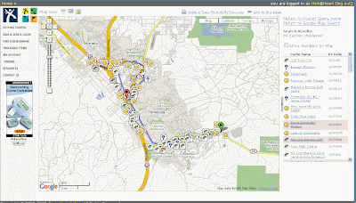
That's it! you now have all the caches within your custom path in a pocket query. From the manage pocket queries page, Click on "preview in Google maps" to see them.

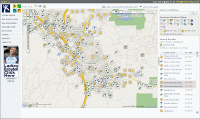
You can see how this allows you to only grab the caches that you want and eliminate a lot that are too far from where you are going. (Unfiltered view below)

You may need to play with it a bit to get the points in Google earth down. It also seems that there is some difference in the location between Google earth and the Google maps on Geocaching.com. You my be able to correct this byadjusting your zoom level while creating the path.
I hope this is helpful. If you know of a way to improve on this process, feel free to link to this post and let us know.


4 comments:
Problem I have is that I have no clue how to make sure the route I get in google maps is the one I get in google earth. Unfortunately, it never matches up, so I do some old-school route planning, which takes longer, but works well for me. :)
HooHaa Blog
heh speaking of old school, we've found looking through caches online then printing out the page with a close up map and putting it in a binder still works the best, then we can flip through quickly and eliminate ones that we'd hate, also then we have plenty to go visit when we find a cache too easily, we starting doing it this way in 2003 and it still works best for us
I really like this entry. It is very helpful. We (in our forums) have talked about doing this but no one knew how. I didn't even use the CAAR feature anymore b/c it always took me a different way, and preferred to do it the way Wendy mentioned because it was the most user friendly. I am going to try doing this technique you mention next time I am roadtripping it.
Great post. Another variation on this concept is to create a path or polygon in Google Earth, and then upload the saved KML file into GSAK as a polygon filter. That way, you don't have to create a route-specific pocket query as all your filtering takes place in GSAK. I give a brief explanation of this in my 05/31/08 post. This is especially useful for areas that you tend to visit more than once, as you can save and re-use the filter in GSAK.
Thanks for teaching me another new trick!
Post a Comment